Showing posts with label floods. Show all posts

Friday, April 8, 2011

Sapsuckers Back Tappin' on Signs

Yellow-bellied Sapsucker in Holden Park

I have been seeing sapsucker arrivals on the birding listserves and with another 60-degree day in the forecast, I headed out to check out the two places in Pepin County where I spotted them last year.  I didn't hear or see them over on Kings Highway in Maxville, so I drove across the flooded Lower Chippewa River (current stage:  12 ft) to Silver Birch Lake. 

Lots of birds on the ice and water at the Lake:  Bald Eagles harassing mergansers, Ring-necked Ducks, Ring-billed Gulls and Common Goldeneyes.  I caught a glimpse of a Common Loon as it dove, then minutes later, heard it yodel.   No sapsuckers in the oaks on the west side of the park.  But the Columbines have leafed out.

My Prius strained back up the hill to the prairies - but it continues to get great mileage (70 miles per gallon for the slow spin around the neighborhood).

I headed down the hill at Holden Park to see if the Eastern Phoebe was back and working on a new nest on the eve of the park outhouse.  It was.  Then I heard a odd metallic tapping echoed through the woods.

I had trouble locating the origin.  Turns out it was right in front of me:  A Yellow-bellied Sapsucker drumming on the RV dumping station sign by the outhouse.   Bad lighting, but I took a picture anyway.  Then both he and the phoebe took off.

I headed over to Alma to take a look at the flooding along the Buffalo and Mississippi (current stage:  13 ft) Rivers.  The Swan Observation deck and campgrounds at Rieck's Lake Park are under water!

Wednesday, September 29, 2010

Fish in the Road


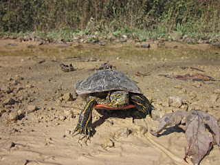
On the way to Meridean via Rustic Road 107, I stopped to help a western painted turtle cross the road. 


That's when I noticed ripples on the surface of the puddle on the side of the road - behind the turtle.


A school of tiny fish stranded by the receding flood waters on along the Chippewa River.

I didn't have a bucket or anything in which to transport them back to the river.   So I left them there.
Dinner for a lucky raccoon or kingfisher?

What species?  I didn't have a clue.

On the way home, I stopped at the library for a fish identification book.

They look like fingerling Gizzard Shad - favorite food of the Bald Eagle.

Monday, September 27, 2010

Flood Waters Crest in Durand

The river crest was forecast for 7am today.  I went downtown to check it out.


You can see the water line on the side of these buildings.


Across the bridge, the floodwaters have spread over County Road P.


USGS predicts the river will get get back to "normal" levels by the end of the week.

I walked the Chippewa River State Trail this afternoon.  There was standing water in the woods and farm fields along the trail.  More than I'd ever seen.

But I will remember this day because of the animals I spotted on the trail:  snails, butterflies, a Belted Kingfisher and a day-flying moth, Hyles lineata, also known as a White-lined Spinx (hummingbird) moth.


White-lined Sphinx moth (head on)
White-lined Sphinx moth
This day-flying month is common throughout the western hemisphere.  But this is only the second time I've ever seen one.  They're active from February to November (2 broods).  The caterpillars feed on several plants including four o'clock (Mirabilis), apple (Malus), evening primrose (Oenothera), elm (Ulmus) and grape (Vitis).  They pupate underground.

Sunday, September 26, 2010

Flood Waters Continue to Rise in Durand


Here's some perspective:

According to the Wisconsin Historical Society, the record-setting flood in the Chippewa Valley took place on September 11, 1884.  The Chicago Tribune reported that the 27-foot flood carried away houses and all the bridges in Eau Claire.  Flood-related losses in the Eau Claire Valley were estimated at $1,500,000.   More than 3,000 homes from Chippewa Falls to Durand were lost.

Here's what's happening today:


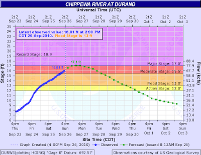
The water level hit the "moderate stage" flooding at 16-feet, and it's still rising.


The best place to see the old flood gage (where the old Hwy 10 bridge crossed the Chippewa) is the deck on the river side of the Corral Bar.


Here's how it looks at 4th and Main Street.  River Street is completely submerged.


Here's the view from the deck at the Corral, looking up-river at the old flood gage (next to Chippewa View Park).  Look for the numbers at the lower left of the gray building.


According to the old gage - at 2pm today, the river was up 14-feet.


The official gage, up-river by the new bridge, is 2-feet higher.  The river level is 16-feet.

I drove across the river to take a look at the flooding at State Rd 25 and County Road P in Waterville Twp.


Then I headed back across the river to check out my favorite rustic road - R107 to Meridean.  It was closed east of the Xcel Energy property at Tyrone.


I wondered if the high water would drive the bullsnakes to higher ground across the road near their winter hibernacula.  As the thought crossed my mind, I spotted one on the road, fattened by a vehicle.


How are the insects handling the water?  If they have wings, they're probably okay.  I spotted several bees, flies and butterflies...

Milbert's Tortoiseshell on the riverside deck at the Corral Bar
Eastern Tailed-blue

Eastern Comma

Clouded Sulphur
And the Woolly Bear caterpillars have started to show up all - crawling across sidewalks, the Chippewa River State Trail and State Road 25. 


Saturday, September 25, 2010

Near Record High Waters in Durand


Looking up-river around noon today, you might not realize the Lower Chippewa River is near record flood stage in Durand, Wisconsin.  

I've lived here for ten years, and I've never seen the river higher.  You can't see the river front road, park and boat dock.    They're all under water.


Here's a down-river view from the Stream Gaging Station at the State Rd 25 Bridge.


And a close-up of the river near the Corral Bar.


Across the bridge, County Road P is closed.


This USGS chart tells the story.  They predict we'll hit "Major Stage" flooding, a new record 17+ feet, Sunday and Monday.

How'd it happen?

Meteorologists say it's due to an excessive runoff from heavy rainfall Wednesday evening through Thursday.  We've had a wet summer.  The ground was saturated.  The water had nowhere to go.

So over the banks it went.

Fortunately, there's no rain in the forecast for next week.